The Great Lismore Flood: Revisiting the use of floodplains
February 29, 2024
Last week saw the release of the NSW State Disaster Mitigation Plan which outlines a blueprint for managing future disasters; this week marks the second anniversary of the great flood at Lismore and places downstream in the Richmond River valley. This is a moment to ask how we are going in NSW as far as the future management of floods is concerned.
We focus here on the way floodplains are and should be used. It is often said that the flood problem, one of the costliest we face in Australia in terms of natural environmental processes, would be largely solved if we removed past urban development from floodplains and prohibited such development in the future. That sounds sensible, but its not quite that simple . . .
Lets define the word floodplain. The standard definition is land that will be inundated in a Probable Maximum Flood (PMF); in other words it is based on an estimate of the worst flood believed possible at a nominated location. Usually, the PMF is rendered in the case of riverine flooding as a level on a gauge next to a watercourse from which the area that will be inundated in a flood of the nominated height can be determined.
Here it must be noted that a PMF is a limiting case and nothing like a standard flood. A PMF or something close to it might be thought of as occurring at a specified location (say Lismore, or Windsor on the Hawkesbury River or Bourke on the Darling) only about every 10,000 to 1,000,000 years on average. In other words it is at the extreme end of potential flood height, extent and presumably severity. It is also at the extreme end of rarity of occurrence.
If we were to remove all urban development in Australia up to the levels likely to be reached by PMFs, we would be removing several hundred thousand dwellings (perhaps 15% of the total stock) along with associated commercial, industrial and community establishments and supporting infrastructure. It is impossible to envisage such a colossal undertaking: not only would it be beyond our resources, it would destroy much of the nations built urban heritage and re-define our towns and cities. The solution would be worse than the problem.
But we could seek to remove the most vulnerable dwellings and other buildings located below the PMF but subject to periodic inundation by floodwaters. This, at least, might give us a task of manageable proportions.
It is not necessary to remove development that might be affected by flooding only extremely infrequently that is, only every several centuries or millenia.
Now consider the matter of future development. The same principle applies: we dont need to prohibit residential and other urban development all the way up to PMF levels. We should, however, re-visit our existing regulations which in most states only permit floor levels of new dwellings above the level that would be inundated in the 1% AEP (Annual Exceedence Probability) flood. This is the so-called one-in-100-years flood event.
We should do this by considering flood levels in the context of individual environments, thinking in terms of the differences in flood consequences between 1% levels and flood heights approaching those of PMFs.
At, say, Walgett and Brewarrina in the far west of NSW, the floodplain is tens of kilometres wide and provides huge flood storage capacity. The difference in the depths experienced in the 1% and PMF events would be well under a metre. By contrast at Windsor, in Sydneys north-west, the difference because of a downstream topographical choke on flood drainage is about 10 metres. It follows that infrequently occurring very big floods, reaching above the 1% AEP level, have far more potential to do harm at Windsor than similarly infrequent big floods on the vast inland plains. We should therefore prevent urban development at greater heights relative to 1% levels at Windsor than in the inland (where, of course, the demand for it is in any case much lower).
This does not mean allowing no development at all on the higher floodplains around towns like Windsor (including places on other rivers flowing to the Tasman Sea). But it does mean that we should be very cautious at higher levels than are currently used to define what is permissible, and thus more restrictive of future urban development.
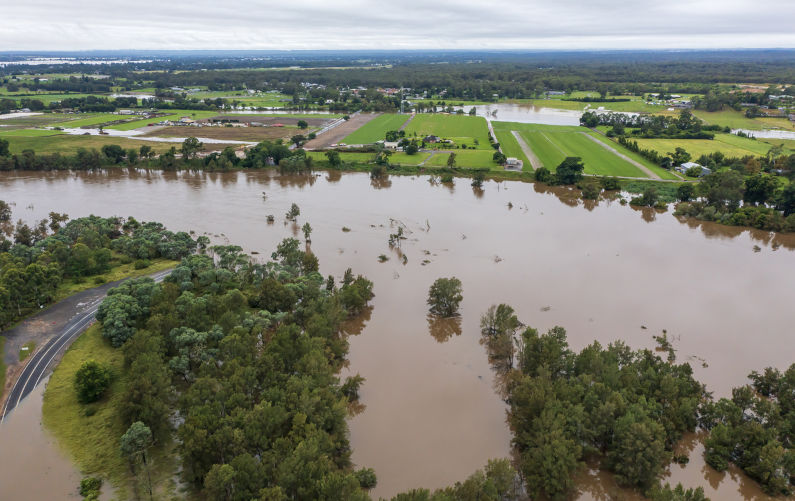
Lismores 2022 experience should be a cautionary case. There, in a flood of a height that might be expected only once on average in several hundred years, many houses were deeply inundated and large numbers destroyed. Eugowra, in the states central west, was similarly devastated a few months later by another apparently extreme flood of locally unprecedented peak height.
Recently, the NSW government revoked existing permissions for some suburban development on the Hawkesbury floodplain above the 1% level, an appropriate move. Sadly, the NSW State Disaster Mitigation Plan is silent on the relationships between flood heights and flood consequences in different locations. It should revisit this matter.
